Description
Carlson SurvCE and SurvPC Modules Available:
SurvCE Basic 6.xx (Contains TS Only)
SurvCE Robotic 6.xx [Requires SurvCE Basic (TS)]
SurvCE GPS 6.xx [Requires SurvCE Basic (TS)]
SurvCE GPS Only 6.xx [Does Not Require SurvCE Basic (TS)]
SurvCE Adv. Roading 6.xx [Requires SurvCE Basic (TS) or (GPS)]
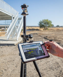
SurvCE Version 6.xx On Board (TS)
Requires GPS, Total station and Robotics
CORE FEATURES
- Highly graphical and intuitive user interface is designed ‘by surveyors for surveyors’
- Easy data exchange due to rich support of CAD file formats and .dwg, .dgn, .shp
- Optional Field-to-Finish: Create drawings intuitively and automatically as you work, saving you time back in the office
- Strong GIS features with optional seamless linking to Esri® in SurvPC
- Export directly in KML format for fast control in Google Earth
- Camera integration allowing assignment of picture to points or lines
- More field capabilities with quick and easy volume calculation and ability to generate points from polylines
- True versatility: SurvCE and SurvPC run on hundreds of GPS and total station models in service today, including Altus, Ashtech, Carlson, Geomax, Leica, Pentax, Sokkia, Spectra-Precision, Stonex, Topcon, and more. See full list at www.survce.com.
- SurvCE/PC are available in more than two dozen languages: English, Spanish, German, French, French (Canadian), Russian, Portuguese, Czech, Dutch, Chinese, Korean, Greek, Italian, Polish, Hungarian, Swedish, Latvian and more.
MAJOR NEW FEATURES: VERSION 6
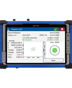
- Enhanced Search icon now available in all live survey screens with access to multiple search methods for TS/RTS
- Voice prompting In Stakeout allows users to keep their eyes on the environment while staking
- Google, Open Street Maps, Esri® Maps, and your own
WMS overlays now available in the field
- GIS Inspector allows instant access to GIS attributing in the map screen
- Surface Inspector enables easy comparison of plan vs. as-built in elevation difference, making it simpler to store and stake the points that matter
- Obstructed Point Stakeout allows guided staking of unreachable points by marking azimuth and distance
- Automatic Backsight Check in the joystick screen makes it easier to check your setup at any time
- GPS Tolerance Band instantly indicates when a tolerance is exceeded in live survey screens
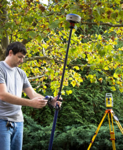
HYBRID+
- Mix and match any RTS and GNSS from Carlson’s vast driver library
- GPS Search is faster than any search method available
- Follow Me keeps the total station pointed where you need it by continuously tracking the GNSS location
- Smart Lock detects when you are slowing down to take a measurement and automatically locks on the prism—ready when you are
- Smart Staking provides directions from the GNSS when the total station position isn’t available, then automatically locks back on the prism when you reach your destination
- Backup Tracking — GPS position is automatically shown when total station is not tracking
- GNSS Sensors work with the total station to allow e-level in total station mode and automatic correction of tilted poles
ADVANCED ROADING
- Powerful Roading: favored by U.S. DOTs and heavy highway contractors around the world
- Comprehensive routines: Slope Staking, As-Built Topo with “Store Sections”, and more
- Advanced functionality for staking intersections and cul-de-sacs using Carlson Road Network Files
POWERED BY ESRI® (SURVPC ONLY)
- Powered by Esri: If ArcMap10, ArcView or equivalent reside on the same Windows tablet, SurvPC ‘finds’ the Esri engine and reads and writes Esri MXD files automatically, or SurvPC can be purchased with an Esri OEM engine built inside
- Intuitively use Esri Maps to perform all survey functions with no downtime learning new software
- Stake out, identify or draw to any existing feature by conventional ‘snap’ selection in Esri, DGN or .dxf
- Create new points in Esri, DGN or .dxf with symbols and formats native to the map
- Learn more in the SurvPC Esri Brochure
Learn More: https://www.carlsonsw.com/product/carlson-survce